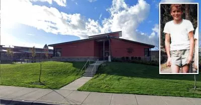
The campus where Ted Bundy abducted Donna Gail Manson
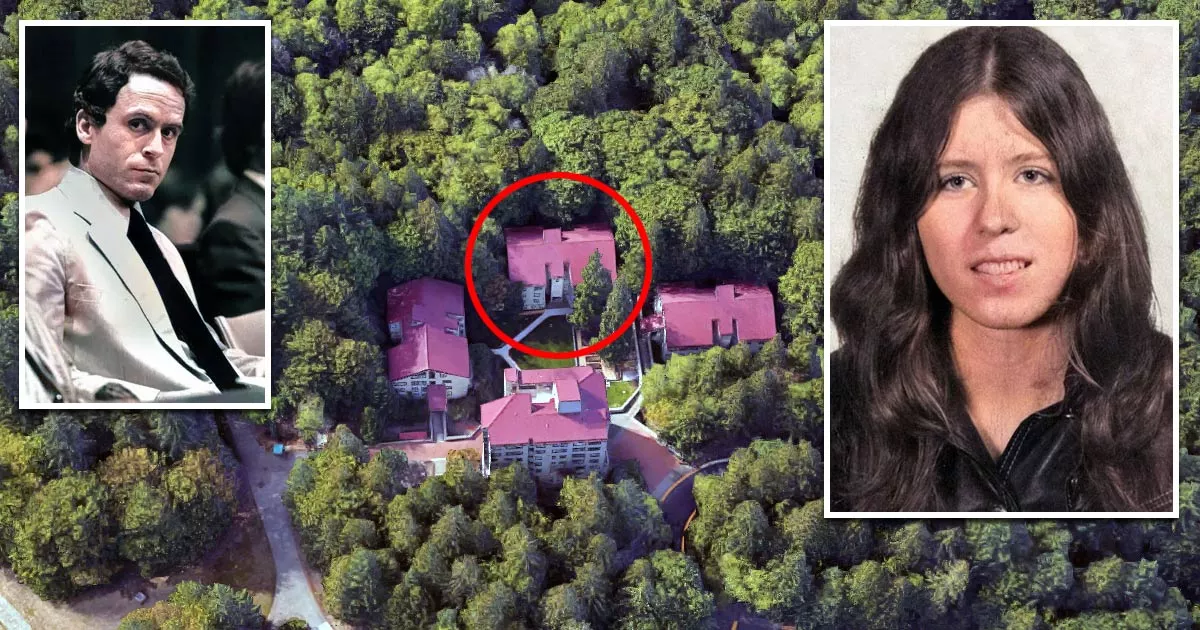
This is the college campus where Ted Bundy abducted Donna Gail Manson.
It is located at Evergreen State College in Olympia, Washington.
On March 12, 1974, Manson disappeared after leaving her dorm building at 4319 Indian Pipe Loop NW.
Although Bundy eventually confessed to murdering the 19-year-old, her remains have never been found.
The disappearance of Donna Manson
At around 7 p.m. on March 12, 1974, Manson left her dorm room to attend a folk dancing class at the nearby College Activities Building.
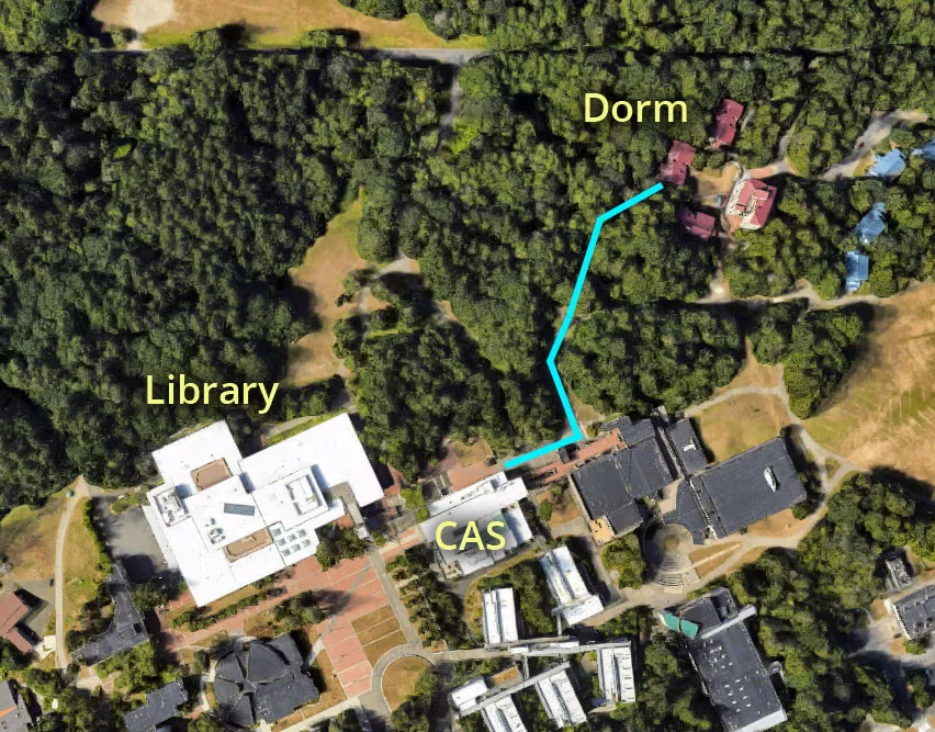
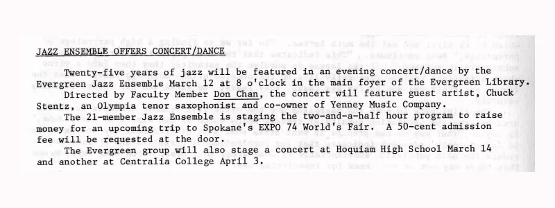
After the class, she was planning on going to see a jazz concert, which was scheduled to start at 8 p.m. in the main foyer of the Evergreen Library.
Tellingly, she never made it to either of these locations.
The route between her dorm and the College Activities Building takes roughly two minutes to walk. Due to the short distance involved, the most plausible theory is that Bundy intercepted Manson shortly after she left her dorm building.
For example, he may have approached the young college student and asked her to help him carry something to his car.
It is also possible that they crossed paths somewhere else, as a campus security guard reported seeing Manson multiple times on a nearby road between 8 p.m. and 9:30 p.m. By that stage, the jazz recital would have been in full swing.
If this sighting wasn't a case of mistaken identity, then it suggests that she was planning on going somewhere else that night. That or she got sidetracked while she was en route to her dance class.

One week passed before she was reported missing
Manson liked to party, hitchhike, and couch-surf. She also had a habit of leaving for days at a time. Consequently, it took nearly a week for one of her roommates to report her missing.
When the investigation into her disappearance finally kicked into gear, many students and staff members had already left Evergreen State College for spring break. Unfortunately, this meant that the police didn't get the chance to interview a number of witnesses until the end of March.
By that stage, many of the finer details may have been lost to the passage of time.
Confession
Bundy confessed to murdering Manson shortly before his execution in January 1989.
During an interview with King County detective Robert Keppel, he said that he buried her headless body at a site on Taylor Mountain.
He also made the highly dubious claim that he had reduced the teenager's skull to ashes by burning it in the fireplace at his girlfriend's house.
Unfortunately, despite two searches of the suspected burial site, investigators were unable to find any trace of her remains.
Manson's murder marked a drastic change in Bundy's M.O.
Up until that point, he had operated within Seattle's University District. However, he had now decided to "hunt" further afield, at a college campus that was more than 70 miles away.
This was also the first confirmed case of him abducting someone from a public place. During his previous attacks on Karen Sparks and Lynda Ann Healy, he had broken into their houses while they were sleeping.
Shortly before his execution, Bundy claimed that he was so drunk during the attack that he had trouble piecing it together. He also described the night in question as "blurry", "incoherent" and "nightmarish".
Manson's body has never been found. To this day, she remains listed as a missing person.
Location
The address and GPS coordinates for the dorm are as follows:
Address
Evergreen State College, Olympia, WA 98505, USA
GPS Coordinates
47.075477, -122.974575
47°04'31.72"N 122°58'28.47"W
Get Directions
Open this location in your preferred maps app:
Photos
Photos of the dorm and other related images.
Security guard sighting
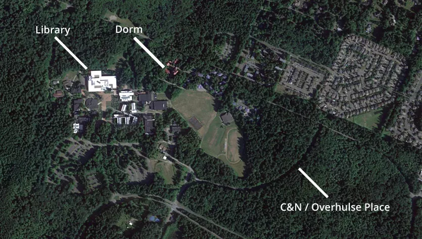
A campus security guard was confident that he saw Manson walking along the C&N road on three separate occasions between 8 p.m. and 9:30 p.m.
In his statement, he said that she was walking back and forth:
The first time I was driving north on what we call the C&N road at approximately 8:00 p.m. or 8:30 p.m. and I observed her walking south. I went over and checked some buildings in the resident area and about 30 minutes later I observed her walking northward. I went into the security office, and about 30 minutes after I had seen her, I again went north on the C&N road and again observed her walking southward.
This sighting is credible for two reasons. Firstly, the security guard knew who Manson was because he had seen her around campus in the past. Secondly, he also told investigators that she was wearing a long maxi coat, which her roommates confirmed.
If he wasn't mistaken, then it means that Manson either got sidetracked or lied to her roommates about her plans.
Many authors believe that Bundy approached the 19-year-old as she was walking toward the library area. However, this sighting raises the possibility that Bundy happened across her elsewhere.
Although Manson did not say that she was meeting anyone, her roommates did note that she changed her outfit multiple times and seemed fixated on her appearance.
Coordinates: 47.074161, -122.964462
Parking Lot F
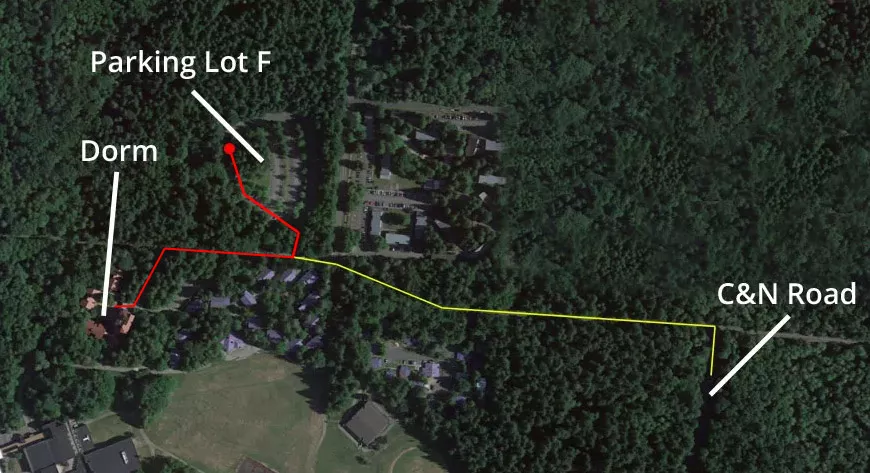
This aerial map shows Manson's dorm, Parking Lot F, and the C&N road that she may have walked along. Note that we digitally removed the buildings above the C&N road because they did not exist in 1974.
During the abductions of Georgann Hawkins and Susan Elaine Rancourt, Bundy strategically parked his Volkswagen Bug in areas that were dark, within walking distance, and slightly off the beaten track.
He typically lured his victims back to his vehicle by feigning an injury and asking them for their assistance in carrying something. Once there, he would wait until his victim's back was turned and then strike them over the head with a crowbar.
This was Bundy's preferred M.O. while he was targeting women in the Pacific Northwest.
Bundy liked to park his car relatively close to his "hunting ground". That way, if a woman did fall for one of his ruses, they wouldn't have to walk too far.
This reduced the chances of them being spotted in public together. It also gave his target less time to have second thoughts.
If we take all of this into account, then it is difficult to look at this map and not see Parking Lot F as a prime location for such an attack:
1. It is a short distance from the campus dorm areas.
2. It is slightly off the beaten path.
3. There is a secluded area on the western side of the lot that is obscured by trees.
4. Aerial images show that it existed in 1974.
Coordinates: 47.077100, -122.972403
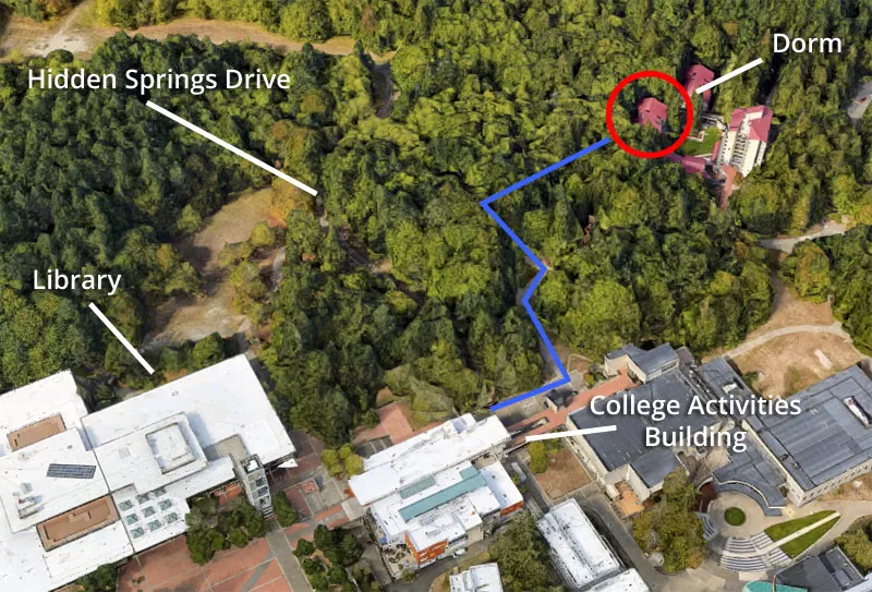
The pathway that Manson may have walked along
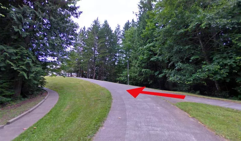
This is a section of the pathway between the dorm building and the library.
The red arrow indicates the direction that Manson would have walked.
A number of true-crime authors have posited the theory that Bundy ambushed the 19-year-old while she was walking along this pathway and then carried her to his vehicle.
However, there are two problems with this theory.
Firstly, traffic in the area was relatively high that evening because there were three different events occurring on the Evergreen campus. Therefore, it stands to reason that this location was pretty busy at the time.
Secondly, this kind of ambush attack does not square with Bundy's M.O. at the time.
All in all, it seems far more likely that Bundy employed some sort of injury ruse to trick Manson into accompanying him back to his vehicle.
Coordinates: 47.074641, -122.975345
Manson had plans to go to the College Activities Building
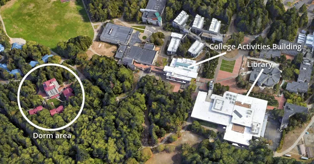
This aerial image shows the College Activities Building and the library. As you can see, they are both beside each other.
Manson was planning on attending a folk dancing class at the College Activities Building. After that, she intended on watching the jazz recital at the library.
However, she did not attend either.
Evergreen State College campus map
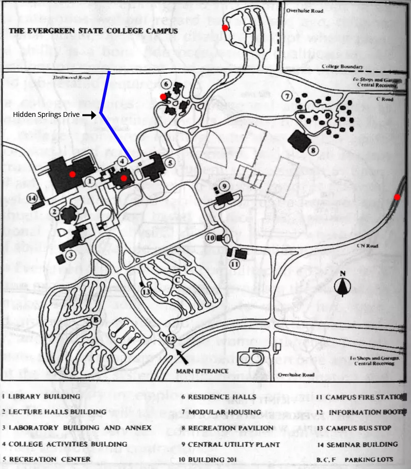
A map of the Evergreen State College campus from the 1975-1977 course catalog. The relevant locations are marked with red dots.
The map appears to have omitted the "Hidden Springs Drive" road. However, earlier aerial photographs show that it did exist at the time. To make up for this, we have drawn its approximate path using a blue line.
Bundy often visited Olympia
Credit card receipts listed in a multi-agency report show that Bundy visited Olympia at least 25 times in 1973 alone. Therefore, it is likely that he knew the area pretty well.
There are also reports that he may have visited the campus in the past.
This falls in line with the theory that most serial killers tend to operate in areas that they are familiar with.
In 1972, Bundy was a member of the Seattle Crime Prevention Advisory Commission, which produced a pamphlet on rape prevention. During his time on the commission, he learned that communication between law enforcement agencies in different counties and states was severely lacking.
Consequently, he understood that operating in multiple jurisdictions would hinder the police's capacity to notice connections between disappearances.
Although he clearly decided that he needed to "branch out" of Seattle and King County, he still selected a place that he knew and felt comfortable with.
Hidden Springs Drive
Another theory is that Bundy parked his car on Hidden Springs Drive. This small road connects the area around the library with Driftwood Road to the north. It is also very close to the pathway that Manson would have walked along.
The problem with this theory is that it seems too close to the library. Due to the level of activity on the Evergreen campus that night, this would have been a very risky spot to carry out an ambush abduction.
Having said that, it would be foolish to rule it out. This is because Bundy often trolled for victims while he was under the influence of alcohol.
Bundy's fireplace story is questionable
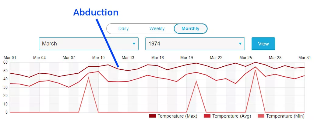
Bundy's story about burning Manson's skull in his girlfriend's fireplace is questionable.
An open fireplace in a residential property would not have reached the minimum temperature that is required to turn bone into ash.
During this part of his confession, he also stated that it was warm outside and that lighting the fireplace was risky on his part because it might have drawn suspicion.
"It's a twist. And it's a lot of work and certainly very risky, under the circumstances. I mean, the kids come home from school, and there's a roaring fire in the fireplace and it's warm outside."
However, historical weather data shows that the temperature in Seattle remained pretty low that week.
The highest recorded temperature that month was 60°F (15.5°C) on March 26, which was two weeks after the abduction.
Bundy was a manipulative liar and a narcissist. Therefore, he may have had ulterior motives for telling such a story.
By that point, Kloepfer had long since broken off contact with Bundy and was seemingly ignoring the most recent letter that he had sent from death row.
His execution was just around the corner, and the woman he once had psychological control over didn't even seem interested in saying goodbye.
Therefore, it is possible that this was an attempt to inflict "revenge" on Kloepfer. In other words, he may have concocted this gruesome story in the knowledge that it would eventually reach her and cause her psychological distress.
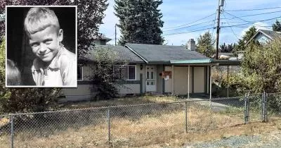
Manson's former house.
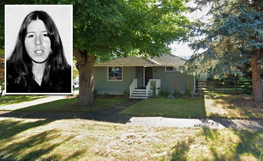
At the time of her disappearance, Manson's parents were living at this house in Auburn, Washington.
Her father, Lyle, passed away in December 2007, following a long battle with Parkinson's disease. Her mother, Marie, died in March 2014 at the age of 91.
Coordinates: 47.309772, -122.210596
Map Viewer
There is more than one location associated with this entry. To view these places on one map, you can use the following feature:
This location belongs to the following categories:
Serial Killers Missing People Ted Bundy's Seattle Locations Unsolved Cases Ted Bundy LocationsClosest Locations
Other locations that are relatively close to this address:
The coffee shop where four Lakewood police officers were shot dead
Roughly 31 miles away.
Crime Location in Parkland, Washington
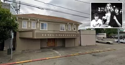
The theater where Nirvana played their first gig
Roughly 32 miles away.
Place of Interest in Tacoma, Washington