Buddy Holly's crash site
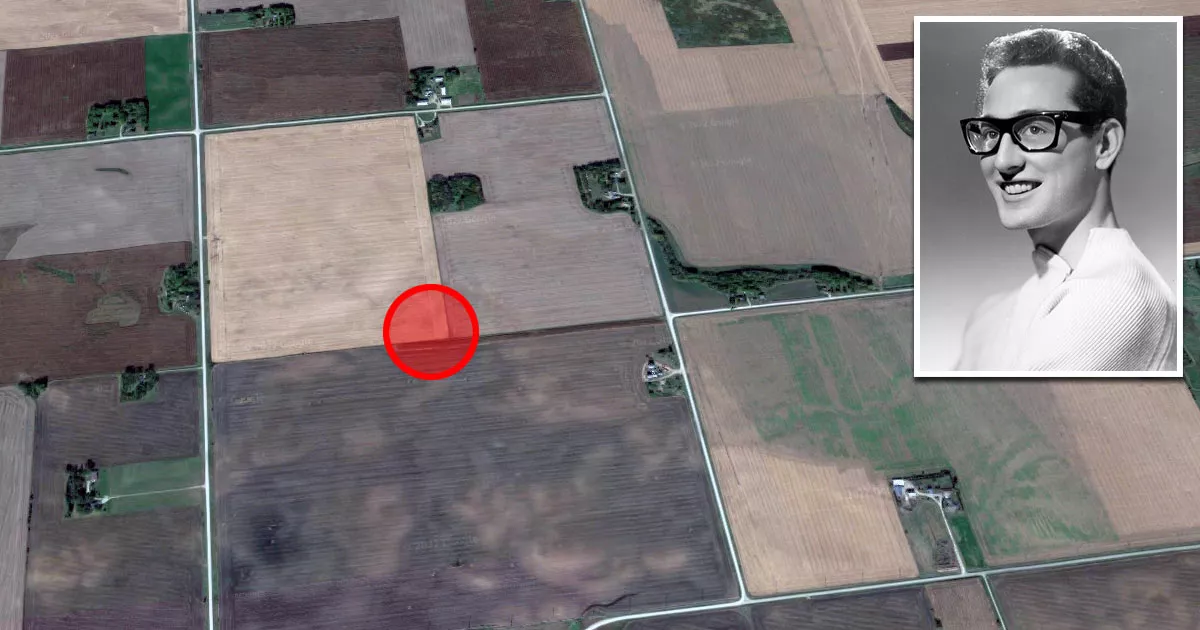
Buddy Holly's crash site is located near the corner of Gull Avenue and 315th Street in Clear Lake, Iowa.
The exact spot is in a cornfield accessible via an unpaved pathway.
The coordinates are 43.22037, -93.38133.
In the early hours of February 3, 1959, Holly, pilot Roger Peterson, and musicians J.P. Richardson and Ritchie Valens died when their aircraft crashed at the site.
The date became known as "The Day the Music Died" after singer Don McLean referenced it in his song "American Pie."

Flight
On February 2, 1959, Holly, Richardson, and Valens chartered a plane to Moorhead, Minnesota.
The group had just performed at the Surf Ballroom in Clear Lake.
By then, the musicians were tired of their grueling and disorganized Winter Dance Party tour, which had zigzagged across the Midwest instead of circling it in an organized fashion.

Holly, having performed at 11 locations in as many days, was reportedly exhausted by bus travel.
Forced to swap vehicles multiple times due to mechanical issues, the musicians found the freezing Midwest weather unbearable.
A private flight would spare them another five-hour drive and allow them to wash their clothes and get some much-needed rest.
Initially, Richardson and Valens were not supposed to be on the flight. The seats were intended for Holly, Waylon Jennings, and Tommy Allsup.
Richardson had come down with the flu and complained that the bus was too cold, so Jennings gave him his seat on the plane.
Valens, who was also feeling ill, asked Allsup for his seat. Allsup agreed to toss a coin for the seat. When Valens won, he allegedly quipped that it was the first time he had "ever won anything in his life."
Crash
Holly chartered the plane from Dwyer Flying Service. The pilot was 21-year-old Roger Peterson.
At 12:55 a.m., the group departed Mason City Municipal Airport in a small Beechcraft 35 Bonanza.
The plane took off to the south before veering north.

Despite having over 700 flight hours, Peterson was certified only for visual flight rules (VFR) and was unfamiliar with the aircraft's gyroscope.
That night, he was flying over a sparsely lit rural area with low clouds. Additionally, Peterson's weather briefing did not warn him about the worsening flying conditions.
Minutes after takeoff, the plane struck the ground at approximately 170 mph before cartwheeling through the field beside Gull Avenue.
The crash site was not discovered until the next day.
The owner of Dwyer Flying Service grew concerned when Peterson did not contact him after several hours.
Suspecting trouble, he flew along the pilot's planned route. Shortly after takeoff, he spotted the wreckage in the field outside Clear Lake.

The coroner's report stated that all four men suffered extensive brain injuries and died on impact.
Authorities disclosed Holly's name to the media before notifying his pregnant wife, Maria. She learned of her husband's death from the news and suffered a miscarriage the following day.
Following the incident, authorities adopted a policy to withhold the names of victims until their families had been informed.
Memorial site
The site is accessible by an unpaved pathway that runs between two fields. The trail is approximately 600 yards (550 meters) long.

Most visitors park on the gravel road beside the entrance. Appropriate footwear is recommended, as the path can become muddy during wet weather.

The area's appearance changes depending on the time of year. In June, the corn is newly planted, but by August, it towers over visitors on both sides.
Location
The address and GPS coordinates for the site are as follows:
Address
Gull Avenue, Clear Lake, IA 50428, USA
GPS Coordinates
43.220372, -93.381339
43°13'13.34"N 93°22'52.82"W
Get Directions
Open this location in your preferred maps app:
Area Information
Clear Lake is a city located in Cerro Gordo County in north-central Iowa.
📍 The site is approximately seven miles north of Clear Lake. It lies west of Interstate 35. The entrance is at the corner of 315th Street and Gull Avenue.
Categories
CelebritiesClosest Locations
Other locations that are relatively close to this address:
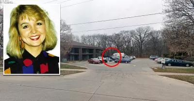
Crime Location · Mason City, Iowa
The apartment lot where Jodi Huisentruit was abducted
Roughly 14 miles away.
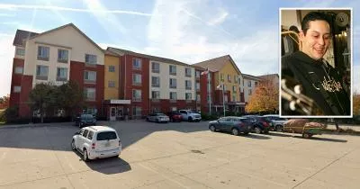
Death Location · Urbandale, Iowa
The hotel where Slipknot bassist Paul Gray died
Roughly 137 miles away.
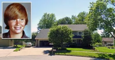

Crime Location · Iowa City, Iowa
The house where Steven Sueppel murdered his family
Roughly 182 miles away.