Southern Airways Flight 242 crash site
This is the location where Southern Airways Flight 242 crashed.
The crash site is situated on the Dallas-Acworth Highway in New Hope, Georgia.

On April 4, 1977, Southern Airways Flight 242 took off from Huntsville, Alabama, and proceeded to fly southeast toward Atlanta, Georgia.
Although the flight crew had been warned about the presence of thunderstorms along their route, they were not updated when weather conditions significantly worsened.
When the pilots encountered one of the storms, they attempted to find a safe path through it. However, the heavy rainfall had negatively impacted their radar system. As a result, they flew straight into a thunderstorm cell that was generating huge amounts of rain and hail.
The severe precipitation flooded the aircraft's jet engines and cracked the windshield. Both engines suffered a flameout due to the massive intake of water. Consequently, the aircraft lost power and started gliding downward.
Realizing the severity of the situation, the crew immediately started searching for locations to make an emergency landing. Due to their location and falling altitude, they soon determined that both of the nearest options were out of reach.
As they continued to glide downward, the pilots saw State Route 381 below and decided that it was their only hope of making a forced landing.
Despite their best efforts, the landing was not a success, as the two-lane highway was too narrow for the Douglas DC-9. Moments after touching the ground, the aircraft struck a gas station, veered to the left, and then crashed into a wooded area that was filled with pine trees.

The Douglas DC-9 broke into several parts after it collided with the trees. Both of the pilots died almost instantly after their cockpit separated from the aircraft and landed upside down.
The impact and subsequent fire killed 72 people. The death toll included 61 passengers, 9 people on the ground, and both pilots. Among the ground fatalities were seven members of the Griffin-Gamel family, who died after the aircraft struck their Toyota compact while they were parked outside a grocery store.

Some of the passengers who survived the initial impact died because they were too badly injured to escape the smoke and fumes.
R&B singer Annette Snell was among the fatalities, as she had been flying back to Florida via Atlanta.

22 people survived thanks to the heroic efforts of the townspeople of New Hope, many of whom responded to the accident with makeshift stretchers, blankets, and bandages that they fashioned out of everyday items.
To this day, Flight 242 remains the worst aircraft disaster in Georgia's history.
Location
The address and GPS coordinates for the site are as follows:
Address
Dallas-Acworth Highway, New Hope, Georgia, GA 30132, USA
GPS Coordinates
33.962478, -84.786787
33°57'44.92"N 84°47'12.43"W
Get Directions
Open this location in your preferred maps app:
Area Information
New Hope is a small town in Paulding County, which is situated in the northwest of Georgia.
📍 It crashed on the Dallas-Acworth Highway in New Hope, Georgia. At the time, it was called State Route 381 (SR 381). The aircraft touched down at the intersection of the Dallas-Acworth Highway and Due West Road. It then continued northward for about 500 yards before crashing into a wooded area on the left.
Photos
Photos of the site and other related images.
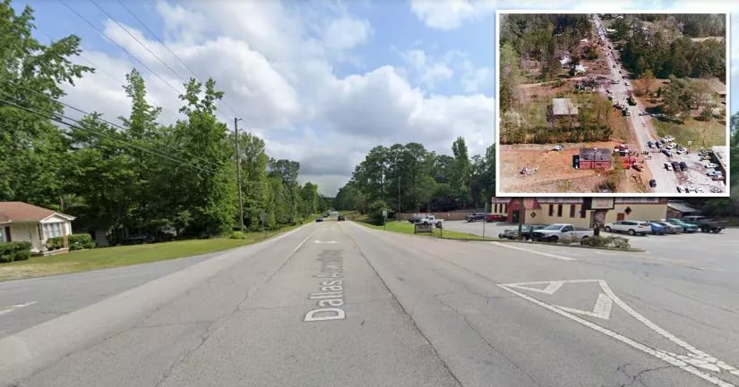
Crash site

The Google Street View image above was captured in May 2022.
It was taken close to the entrance of Bickers Road, which is just 270 feet south of the crash site.
The red circle highlights the general area where the aircraft crashed into the woods.
Flight 242 memorial

A memorial for Flight 242 was built at the southern end of the New Hope Cemetery. It is roughly 720 yards (660 meters) south of the crash site.
The large stone monument in the middle lists the names of each fatality and survivor.
Coordinates: 33.957774, -84.790535
Route

This is a north-facing aerial image of the Dallas-Acworth Highway. Back in 1977, this stretch of road belonged to Georgia State Route 92.
When the aircraft landed, its left wing struck a gas station on the southern corner of Route 92 and Bickers Road. This caused it to veer off into the wooded residential area on the left.
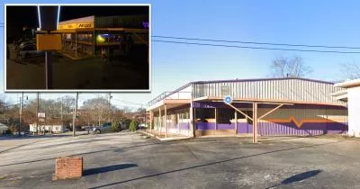
Newman's store

Newman's grocery store sat on this corner beside Bickers Road.
Seven members of the Griffin-Gamel family were killed when the plane's wing struck a gas tank beside the store.
Newman's was completely gutted by the ensuing explosion and fire. Fortunately, many staff members and customers were able to escape via a back door before the building was engulfed in flames.
Coordinates: 33.961630, -84.787407
Closest Locations
Other locations that are relatively close to this address:
The Palace Arcade from Stranger Things
Roughly 18 miles away.
Filming Location in Douglasville, Georgia
Benny's Burgers from Stranger Things
Roughly 19 miles away.
Filming Location in Lithia Springs, Georgia
Mike Wheeler's house from Stranger Things
Roughly 32 miles away.
Filming Location in East Point, Georgia
