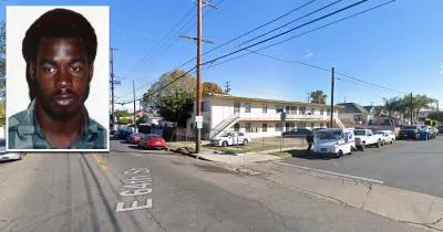
The sidewalk where Mark Diggs was murdered
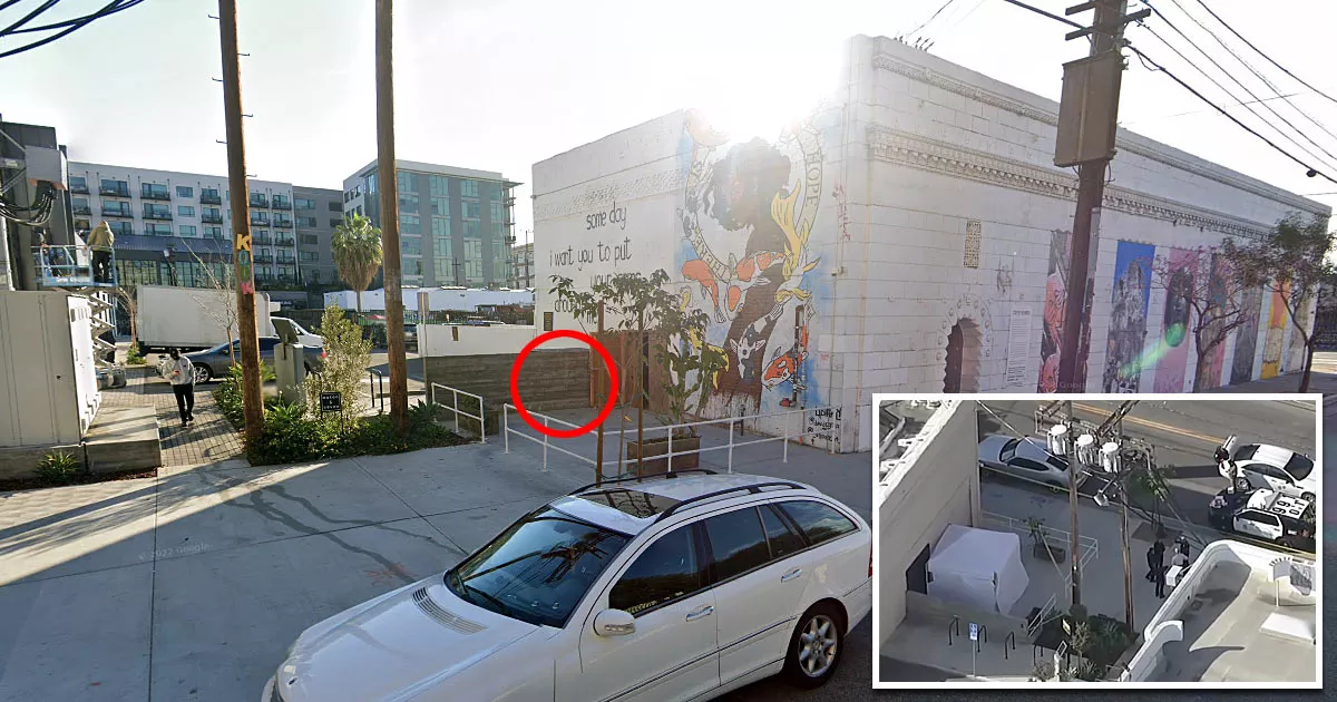
This is the sidewalk where Mark Diggs was murdered.
It is situated on the northern side of 696 Mateo Street in Los Angeles, California.
Diggs is the second known victim of a suspected serial killer who targeted homeless men in late November 2023.
At roughly 4:45 a.m. on Monday, November 27, 2023, the 62-year-old pushed his shopping cart to this section of the sidewalk on Mateo Street.
While he was plugging his phone into a charger and preparing to turn in for the night, an unidentified gunman approached him and shot him in the head.

Diggs' murder took place one day after the first known victim, Jose Bolanos, was found dead in an alley in South Los Angeles.
The two locations are 11.6 miles apart.

Following Diggs' murder, a nearby security camera captured a gray BMW driving northbound on Imperial Street, in the direction of 6th Street.

Google Maps shortcut
On December 2, 2023, the LAPD arrested a man named Jerrid Joseph Powell (33) in connection with the crimes. Powell's gray 2024 BMW was determined to be at all three crime scenes. Furthermore, a gun found in his vehicle proved to be a match with the weapon used in the murders.

When the arrest took place, Powell was already in custody for a homicide that occurred during a home robbery on Thursday, November 30, 2023.
Address
The address and GPS coordinates for the sidewalk are as follows:
Address
696 Mateo Street, Los Angeles, CA 90021, USA
GPS Coordinates
34.035061, -118.232248
34°02'06.22"N 118°13'56.09"W
Get Directions
Open this location in your preferred maps app:
Area Information
The shooting took place in the Arts District neighborhood of downtown Los Angeles. It lies to the east of Skid Row.
📍 It is roughly 140 feet north of the intersection between East 7th Street and Mateo Street.
Map Viewer
There is more than one location associated with this entry. To view these places on one map, you can use the following feature:
Closest Locations
Other locations that are relatively close to this address:
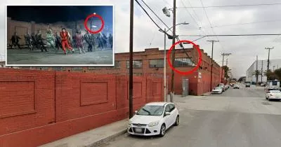
Filming Location · Los Angeles, California
The location where Michael Jackson's zombie dance scene was filmed
Roughly 3 miles away.
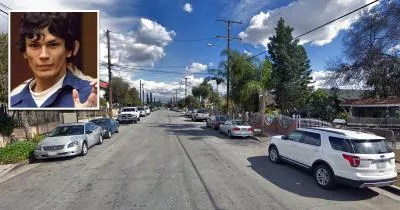
Arrest Location · Los Angeles, California
The location where Richard Ramirez was arrested
Roughly 3 miles away.
Crime Location · Los Angeles, California
The corner where Crips founder Raymond Washington was killed
Roughly 5 miles away.