Home » John List's house » Map
Map: John List's house
431 Hillside Avenue, Westfield, NJ 07090
The house is marked below.
GPS Coordinates
40.664600, -74.358146
40°39'52.56"N 74°21'29.33"W
Get Directions
Open this location in your preferred maps app:
Main Article
The map above belongs to the following article:
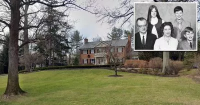
The house where John List murdered his family
Crime Location in Westfield, New Jersey
In November 1971, John List murdered his family at this address in Westfield, New Jersey.
Following the killings, he went on the run for 18 years.
Follow
Follow us on social media: