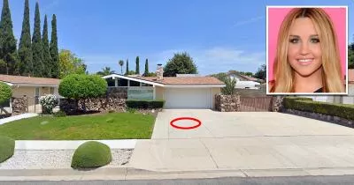
Map: The driveway where Amanda Bynes started a fire
239 East Avenida De Los Arboles, Thousand Oaks, CA 91360
The house is marked below.
GPS Coordinates
34.217741, -118.871331
34°13'03.87"N 118°52'16.79"W
Get Directions
Open this location in your preferred maps app:
Main Article
The map above belongs to the following article:
Place of Interest · Thousand Oaks, California
The driveway where Amanda Bynes started a fire
In July 2013, former child actress Amanda Bynes was placed under a mental health evaluation hold after she started a fire on this driveway in Thousand Oaks, California.
One month later, her mother was granted temporary conservatorship over her affairs.
Follow
Follow us on social media: