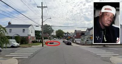
Map: The location where rapper Stretch was killed
112th Avenue, Queens, NY 11429
The corner is marked below.
GPS Coordinates
40.705059, -73.746985
40°42'18.21"N 73°44'49.15"W
Get Directions
Open this location in your preferred maps app:
Main Article
The map above belongs to the following article:
Death Location · Queens, New York
The location where rapper Stretch was killed
In the early hours of November 30, 1995, rapper Randy Walker (Stretch) was shot dead during a car chase at this corner in Queens, New York.
It is believed that his murder was drug-related.
Follow
Follow us on social media: